Overview of Mt. Rinjani: Indonesia’s Second Highest Volcano
Nestled on the enchanting island of Lombok in Indonesia, Mt. Rinjani stands as a geological marvel and a prominent natural icon. With an elevation of 3,726 meters (12,224 feet), it is the second-highest volcano in Indonesia and a vital part of the island’s ecological and cultural landscape. The mountain’s majestic presence draws thousands of adventurers, nature lovers, and spiritual seekers annually, all eager to explore its rugged terrains, stunning vistas, and rich biodiversity. As an active stratovolcano situated within the Rinjani Volcanic Complex, Mt. Rinjani offers more than just scenic beauty—it is a testament to Indonesia’s dynamic volcanic activity and natural history.
Geographical Location and Significance
Mount Rinjani is located within the Lombok island at the heart of the Gunung Rinjani National Park, a protected area covering over 41,330 hectares. This strategic position places it in the West Nusa Tenggara province of Indonesia, specifically within North Lombok Regency. Geographically, Rinjani straddles a major transition zone between the Sunda and Wallacea biogeographical regions, contributing to its extraordinary biodiversity. The volcano’s prominence dominates the landscape, and its caldera, known as Segara Anakan, is home to a large freshwater lake called Lake Segara Anak, which is significant both ecologically and culturally.
Rinjani’s prominence influences local climate patterns, and the surrounding landscape features terraced rice paddies, lush forests, hot springs, and waterfalls that contribute to the region’s ecological richness. Its position and activity have played a key role in shaping the cultural identity of local communities, who regard the mountain as sacred, often engaging in traditional ceremonies to honor deities believed to reside within the volcano.
Historical Eruptions and Volcanic Activity
Mt. Rinjani’s history of volcanic activity spans thousands of years, with its most recent eruption occurring in 2016. This active volcano has exhibited periodic eruptions, mostly characterized by ash plumes, lava flows, and geothermal activity, reflecting its status within the Pacific “Ring of Fire.” The first recorded eruption dates back to historical times, but geological evidence suggests previous eruptions occurred well before human documentation.
The 2015-2016 eruption event was notable for its ash emissions that reached up to 6 kilometers into the atmosphere, affecting local air quality and flight routes. Despite its active status, Rinjani’s eruptions are frequently preceded by tremors and increased geothermal activity, allowing authorities to monitor and warn populations around the volcano.
These eruptions have shaped not only the landscape but also the cultural narratives of the local Lombok people, who see the volcano as a powerful entity with divine significance. Continuous monitoring by the Indonesian Center for Volcanology ensures safety and scientific understanding of Rinjani’s behavior.
Unique Features and Natural Beauty
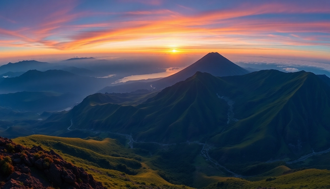
Rinjani’s allure extends beyond its volcanic stature. The mountain boasts several unique features that make it a geological and ecological treasure. The most prominent is the caldera lake, Lake Segara Anak, which is approximately 200 meters deep and offers stunning turquoise waters surrounded by lush green slopes. This volcanic crater lake is one of the largest in Southeast Asia, serving as a habitat for diverse aquatic life and hosting ritual ceremonies by local communities.
The mountain’s diverse terrain comprises rugged volcanic craters, geothermal hot springs like Kalock Banjar, and expansive savannahs that bloom with wildflowers during the dry season. The summit view from Mt. Rinjani rewards trekkers with panoramic vistas of neighboring islands, including Bali and Sumbawa, on clear days. The landscape is also punctuated by spectacular waterfalls, such as Sendang Gila and Tiu Kelep, which cascade through mossy forests, providing serene environments for reflection and adventure.
Guided Trekking and Climbing Routes on Mt. Rinjani
Popular Trekking Paths: Sembalun and Senaru
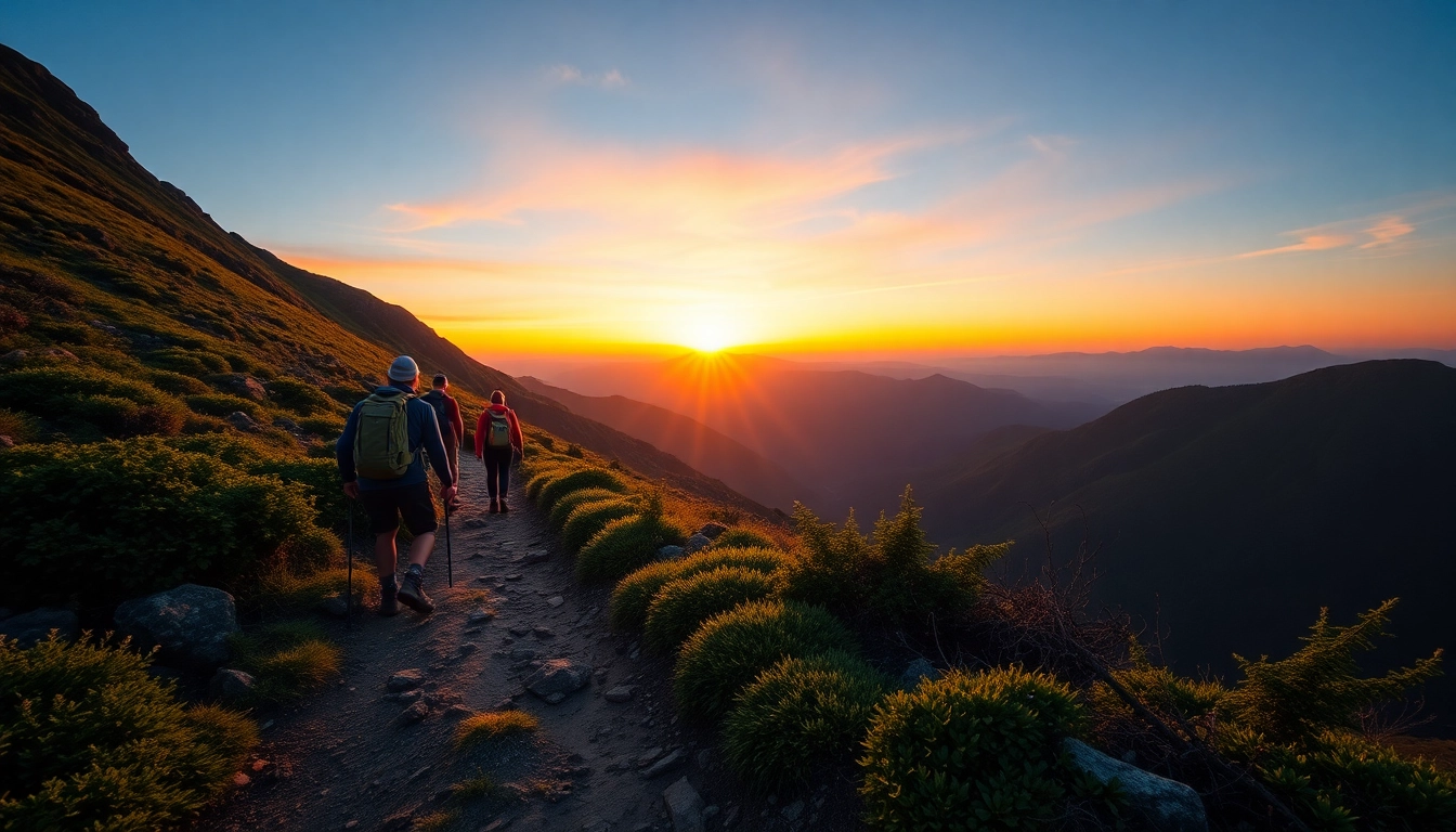
The two primary routes to summit Mt. Rinjani are the Sembalun and Senaru paths, each offering unique challenges and scenic experiences. The Sembalun route is favored for its gradual ascend, covering approximately 27 kilometers over two to three days. Starting from the village of Sembalun Lawang, this trail winds through rolling grasslands, lava fields, and alpine meadows, providing expansive views of the surrounding islands and the volcano itself.
Conversely, the Senaru route begins in the town of Senaru, renowned for its lush rainforests, waterfalls, and a more challenging terrain. This ascent tends to be steeper, often favored by experienced hikers seeking a more rugged adventure. Both paths require proper planning, but Sembalun offers a slightly gentler incline, making it accessible to moderately fit trekkers.
Regardless of the route chosen, both paths converge near the summit, where trekkers witness the majestic crater rim, Lake Segara Anak, and surrounding volcanic formations.
Preparation Tips and Essential Equipment
Mount Rinjani’s terrain and weather conditions demand thorough preparation. Essential gear includes durable hiking boots with ankle support, thermal clothing for cold nights at high altitudes, and windproof jackets due to unpredictable weather. A good quality sleeping bag, trekking poles, headlamps, and sufficient food and water supplies are vital for safety and comfort.
Physical preparation is equally important. Endurance training, including long hikes with loaded backpacks, improves stamina. Acclimatization for altitude sickness is advised, especially for those unfamiliar with high-altitude trekking. It’s recommended to train core strength, cardio, and flexibility beforehand.
Guides, Permits, and Safety Measures
Organizing a trek with authorized guides enhances safety and enriches the experience. Local guides are well-versed in terrain, weather patterns, and emergency procedures. Guide fees typically include permits, which are mandatory for access to the national park and the mountain itself.
Ensuring safety involves checking weather forecasts, carrying communication devices, and informing authorities of your itinerary. Trekkers should also be aware of volcanic activity alerts issued by the Indonesian Center for Volcanology to avoid unnecessary risks.
Respect for local customs and ecological sustainability is crucial. Using eco-friendly gear, minimizing waste, and supporting community-based tourism help preserve the mountain’s natural beauty.
Wildlife, Flora, and Conservation Efforts at Rinjani
Rich Biodiversity Within Rinjani National Park
The Rinjani National Park is a biodiversity hotspot, hosting a variety of flora and fauna unique to the Wallacea ecological transition zone. The lush forests support species such as the ebony wood, cinnamon, and rare orchids. Birdwatchers can spot hornbills, eagles, and endemic species like the Rinjani scops owl.
The park’s diverse ecosystems include montane forests, savannahs, and crater lakes that sustain amphibians, reptiles, mammals, and insects, many of which are endemic or endangered.
Conservation Challenges and Initiatives
Despite its ecological significance, Rinjani faces threats from illegal logging, habitat encroachment, climate change, and unregulated tourism. The Indonesian government, through the Ministry of Environment and Forestry, has implemented conservation programs focusing on habitat preservation, reforestation, and community engagement.
Organizations collaborate with local communities to promote sustainable practices, such as eco-tourism and environmental education, to mitigate human impact.
Responsible Tourism and Eco-friendly Practices
Visitors are encouraged to adopt responsible tourism principles: carry out all waste, avoid disturbing wildlife, and stick to designated trails. Supporting local guides and purchasing locally produced goods help boost community welfare and foster a conservation mindset.
Visitor Experience and Highlights of Mt. Rinjani
Must-See Destinations and Viewpoints
Beyond reaching the summit, Rinjani offers a host of captivating sites. The view from the crater rim provides sweeping vistas of Lombok, Bali, and the surrounding seas. The hot springs near the crater base offer relaxing baths after strenuous hikes. The waterfalls at Sendang Gila and Tiu Kelep are scenic spots perfect for cooling off.
The Lake Segara Anak itself is an iconic highlight, especially when viewed from the summit or the crater rim. Sunrise and sunset vistas atop Rinjani are among the most photogenic and soul-stirring experiences.
Best Time to Visit and Weather Conditions
The ideal period for trekking Mount Rinjani is during the dry season, from April to November, when weather conditions are generally stable and rainfall is minimal. During this period, trekking routes are accessible, and views are clearer.
The rainy season (December to March) sees increased cloud cover, rain, and potential volcanic activity, making hikes more hazardous and less scenic. Always check current weather updates and volcanic activity reports before planning your trip.
Photogenic Spots and Cultural Significance
Rinjani’s breathtaking landscapes are ideal for photography, from panoramic shots of the caldera, lake, and mountain peaks to macro photography of endemic flora and fauna. The local Lombok people revere Mount Rinjani as a sacred mountain, often performing traditional rituals and offerings to honor the spirits dwelling within.
Experiencing local culture—through festivals, crafts, and culinary delights—adds depth to your adventure and fosters appreciation for the mountain’s spiritual significance.
Planning Your Rinjani Excursion: Practical Tips
Entry Fees, Guides, and Accommodation
Entrance to the Gunung Rinjani National Park incurs a permit fee, which varies based on nationality and duration of stay. Hiring an authorized guide is mandatory; guide costs typically range around Rp. 350,000 per day, with additional charges for porters or equipment assistance.
For accommodation, options range from basic guesthouses in Sembalun and Senaru to eco-lodges near the park entrance. Many trekkers opt for multi-day camping, requiring portable gear and permits.
Health Precautions and Physical Preparation
The high-altitude trek demands robust physical fitness. Prior to your journey, incorporate cardio, strength, and endurance training. Altitude sickness is a risk; acclimatize gradually and stay hydrated. Consult healthcare professionals about vaccinations and altitude medications.
Carry a personal first-aid kit, including blister treatments, pain relievers, and emergency supplies. Recognize symptoms of altitude sickness and prioritize safety over achievement.
Booking Guides and Navigating Local Services
It is advisable to book guides and permits in advance, especially during peak seasons (June to August). Many local operators offer packages that include transportation, accommodation, and trekking arrangements. Verify credentials and reviews before hiring.
Ensure all bookings are official and include detailed itineraries. Use reputable agencies that follow eco-friendly practices and prioritize safety.